Our Solutions
Smart Living GIS Visualisation Eco System
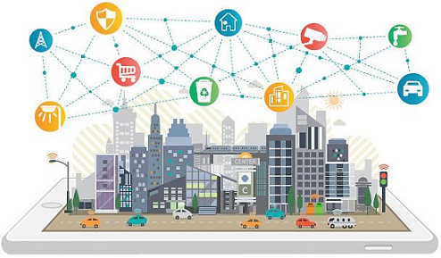
Our Web based Smart Living 3D GIS Engine simulate models for events processing and supports different Operating Systems enabling new business models.
The turn key objective is the identification of the environmental, social, and economic indicators used in order to build smart living models. Location specific decision making for improving socio-economic development, the quality of life, land use, transport and user needs, classified & evaluate. The 3D GIS Engine solution enables Big Data analytics and Alert methodologies to monitor data coming from different sources.
IOT Environmental Monitoring
Our 3D based Air Quality Indexing Solution will access and host emissions data, manipulate it and produce modelled emissions with suitable spatial scales for National to Urban outdoor air quality 3D modelling and analysis.
Objectives :
Urban Outdoor Air Quality 3D Modelling
Air Quality Exposure Modelling
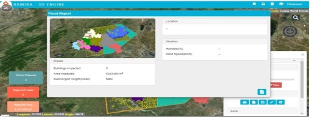
IOT Flood Modeling Solutions
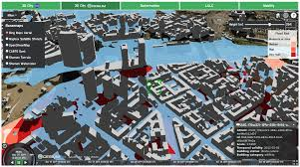
This tool is about simulation of flood, river and sea level rise on 3D Platform through which user will be able to analyze and make decisions for the course of actions in the specific area of impact.
Objectives :
3D GIS Model
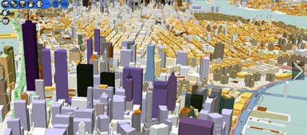
This tool is the base of Web based 3D visualization software. Manages all the data and services. Renders all standard GIS specific data formats. Users and citizens can investigate their location of interest and perform analysis.
Ground Water 3D Modeling
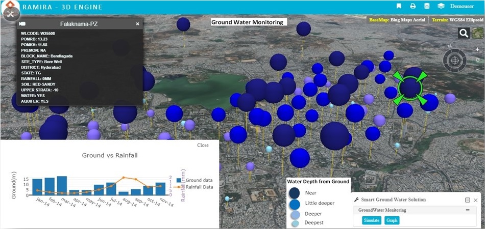
Ground water has become the major source of water to meet the requirements of domestic, industrial and irrigation sectors. We processed bore well datasets, rain fall datasets, soil type datasets and rendered on to 3D engine for visualization, analysis and reports. Based on the depth of the water in the bore wells we classified the water availability as water bubbles with different colors and size.
Objectives :
3D Agricultural Workflow
3D GIS Engine offers a comprehensive collaborative platform to conjoin industry specific applications with spatial and non-spatial data. It presents with a configurable model for 3D elements like Agriculture, Environment, Disaster Management, Assets, Civic applications in a single working platform as an Accelerator . 3D GIS Engine will come as a ready-to-play kind of approach for clients which will reduce development efforts, cost and time.
Bussiness Problems
Tackle challenges in the field by converting images, data into information to maximize yield, operational efficiency, protection, storage and management.
Solution
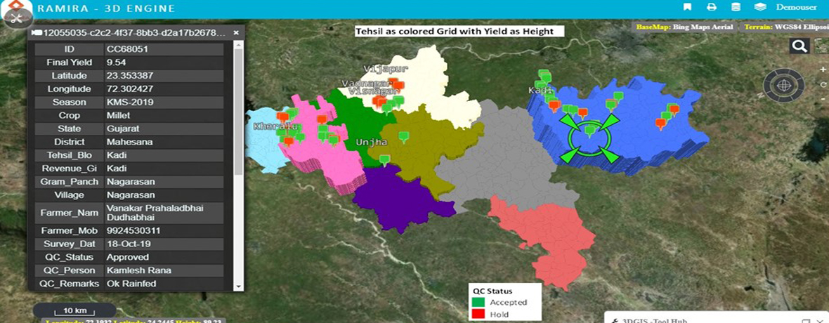
3D Crop Yield Modeling Solutions
Crop yield data of 9 districts spatial boundary dataset, rain data and soil data received. We processed all data sets and rendered on to 3D engine for visualization, analysis and reports. Based on the yield output from each Tehsil, height factor (z factor) classified into the spatial representation.
Objectives :
3D Crop Yield Flood Modeling Solution
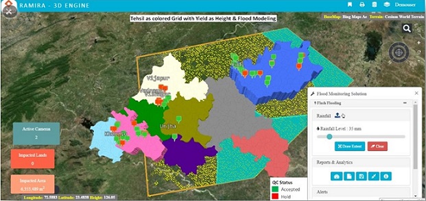
On the Crop yield data, Flood simulation modeling applied with flash rain fall data. User will be able to analyze and make decisions for the course of actions in the specific area of impact.
Objectives :
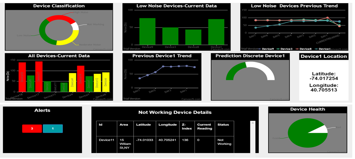
Device Management
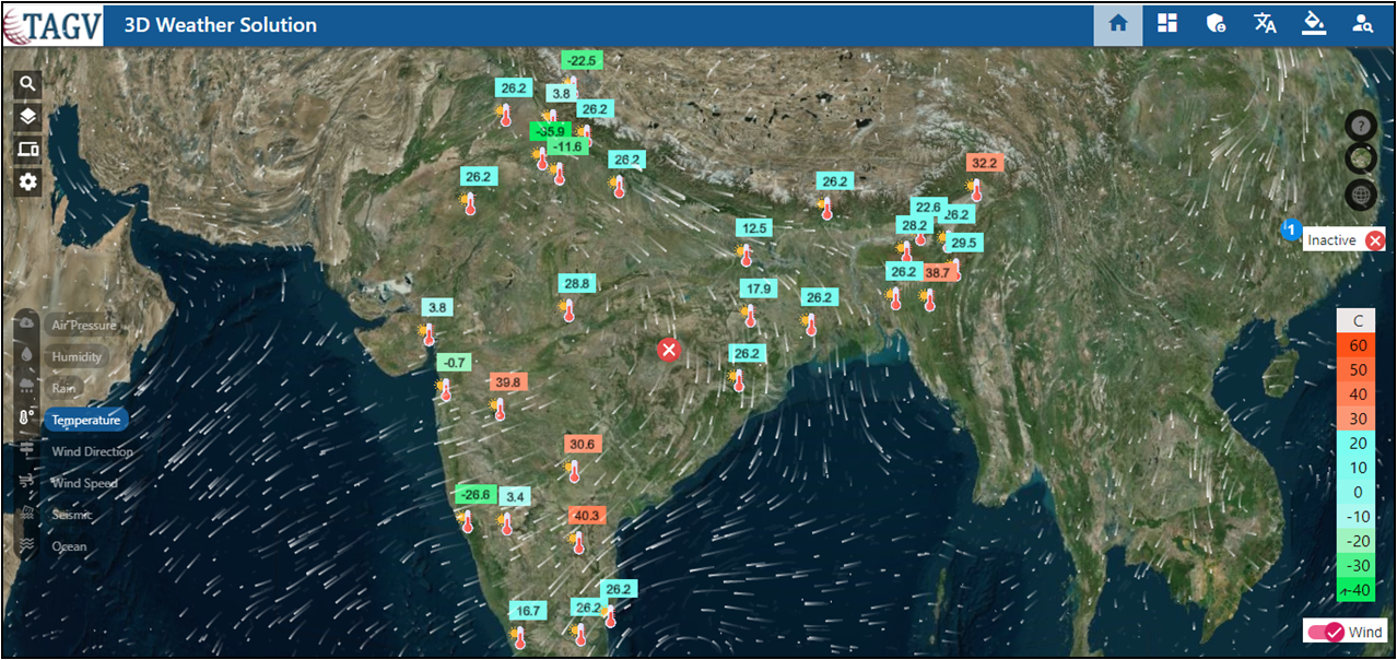
Our Device Management Application shows the weather data of individual parameters with respected units and their location on map from weather station data.
Objectives :
Device Management Reports
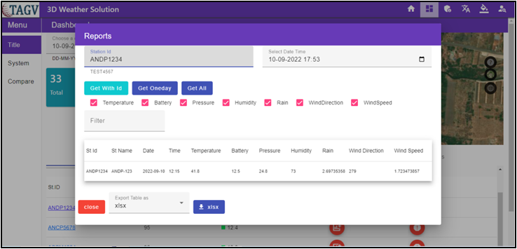
Our Device Management of Reports provide valuable information of weather data.